
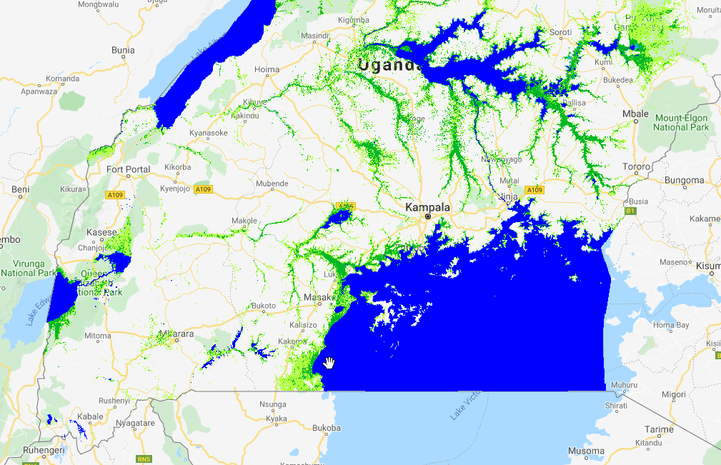
Over the past years the GlobWetland Africa team has worked together with the Ramsar Centre for Eastern Africa (RAMCEA) and national agencies in Uganda to develop a monitoring system for reporting on SDG Indicator 6.6.1, on the Change in the extent of water-related ecosystems over time. The work has been supported by the Global Partnership on Sustainable Development Data (GPSDD) and the project was leveraging developments under GlobWetland Africa to produce a national baseline mapping of wetlands in Uganda using all available Sentinel-1 and Sentinel-2 imagery from 2016-2017. In addition, an online web interface has been designed to produce infographic report sheets on change in the extent of water-related ecosystems and for efficient communication to stakeholders.
One of the other key aims of the project was to use the implementation in Uganda as demonstration case for uptake of the tools and methods by the other RAMCEA member countries This was obtained through participation of key staff from Kenya, Tanzania, Rwanda and Burundi in the training workshops, and by delivering guidance documents on “lessons learned” and “roadmap” for a roll-out.

“The interesting thing about this project is that it has a built-in component of rolling out the program. Wetlands are important water systems in Uganda and continue to be highlighted by the SDGs, and a good starting point for restoration is providing a good mapping inventory of the wetlands. We are therefore confident that the project has got a good potential of applicability and by maintaining a focus on trainings and knowledge sharing, we see an opportunity for rolling this method out to other countries” – Paul Mafabi (Director of Environmental Affairs, RAMSAR/RAMCEA).
The baseline wetland inventory map for Uganda can be viewed on the online portal:
http://uganda-wetlands.dhigroup.com/